Not very long ago, if you wanted to know where a particular person was buried, you had to look through paper records kept onsite at the cemetery. Hand-drawn maps were eventually replaced by searchable online maps, which were often updated and maintained by the public. These crowd-sourced maps were often incomplete or incorrect. However, with the availability of drone technology, digital cemetery mapping is growing in popularity and is immensely improving upon previous cemetery mapping techniques.
I’m Bertus Fick, the COO of OpusXenta, and I fly drones used for cemetery mapping. This new technology gives cemeteries the tools they need to take control of their own cemetery mapping system and maintenance. Digital mapping allows them to create and deliver a unique and helpful cemetery experience for everyone, from family members to sales staff.
What is Drone Mapping?
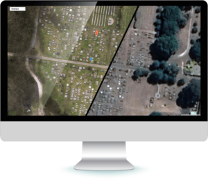
Digital cemetery mapping involves defining the boundaries of plots, buildings, plumbing and wiring, and points of interest within a cemetery so that they can be viewed and maintained electronically. One way of capturing a digital map is through the use of a drone.
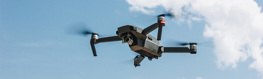
Drones aren’t just for kids. They’re not just toys. In digital mapping, a drone is flown over the property to capture the images. Once that process is done, the rest is as simple as loading locations, a process we refer to as drawing a polygon, which means to draw lines around the graves and other areas you want to label.
Sure, the first time, it can be a big job depending on the size of your cemetery. But maintenance is easy and cost-effective. Most customers are excited that they have complete control over their cemetery for once and can create their own Explore the innovative use of drone technology in cemetery mapping and its benefits.
A La Carte Mapping Options
Most companies involved in digital cemetery mapping not only charge to create the polygons, but also charge to maintain the map and cemetery mapping system. This means every time you create new plots; these companies charge you to enter the updated map into your system. Every time you add plots/sections, you get charged to add them.
In contrast, OpusXenta has created an a la carte system that gives you the freedom to customize options to fit your cemetery mapping budget. We give you the flexibility to choose how the work gets done.
For instance, you may choose to have us fly the drone, take the aerial photos, and draw the polygons to identify the plots, or you could save money by creating the polygons yourself. Either way, the final result is a completed cemetery mapping system with control over maintenance and changes.
DIY Imaging
Another option is to purchase a drone and fly it yourself whenever you need to update images. OpusXenta can help you choose the best drone to buy for your particular situation.
Purchasing a drone is not for every cemetery; however, it could be warranted in certain situations. Owning a drone is a great option for organizations with more than one cemetery location or need to retake photos two to three times each year to update inventory after selling plots. If you consider the cost of the drone versus the cost of paying a company to fly one for you in an ever-changing cemetery, the investment pays for itself very quickly.
Many people fear that flying the drone will be an all-consuming job that spans weeks, but that’s far from the truth. Usually, it only takes a single day to take all of the photos, but you will need to invest the time it takes to obtain a remote pilot’s license. Adding the polygons and information generally takes another day or two at the computer.
Best Time to Photograph
Most people choose to take the photos in the winter to prevent shadows from appearing in the images. The drawback to this is that you cannot showcase your beautiful summer foliage. However, there’s a way to offer beautiful summertime pictures of your cemetery without dealing with distracting shadows. Flying the drone for a few hours each day while the sun is high in the sky will allow you to capture that sharp summer feel. If you have a groundskeeper help, you can easily cover the whole property in a few days. With your own drone, whichever season you choose for taking photos, the choice is yours.
Quality Counts
Most cemetery mapping tools use Google Earth, and while it’s a great cost-effective GPS system, it has limitations when it comes to clarity and accuracy for zoomed-in images. Drones provide much clearer, higher quality images. We use a twenty-megapixel drone, which offers sharp, detailed images and 5cm accuracy of your cemetery, from the monuments themselves to the mausoleum to the large azalea bushes that have grown there for 70 years. In some cemeteries, drones can be flown around 40 meters (or 130 feet) above the ground, resulting in amazingly clear pictures. In contrast, Google Earth uses photos from satellites in space, which is why the difference in quality is night and day.
Cost Effective Surveying
Our services are much more affordable than you might think. In fact, they are more cost-effective than traditional land surveys, plus you get higher-quality results in less time.
Traditional land surveying is time-intensive and costly because of the time involved in taking measurements and drawing the maps. Cemeteries that use traditional land surveying typically only use these services every three to four years, but cemeteries change much more often; this affects the accuracy of the maps. Drone mapping is much more cost-effective than land surveying.
To further improve cost-effectiveness, our maps offer copy-and-paste and drag-and-drop capabilities in the drawing phase. In addition, there are also color-coding options for greater personalization. For example, you have the ability to add information to specific plots, such as identifying which interments are war heroes for your cemetery mapping system.
Other Options
In this article, we’ve explored different options for cemetery mapping. There are different options available with differing price points. I think I’ve made it pretty clear, drone mapping is not only the most affordable option, but it also provides the highest quality too. In a few days, you can have your cemetery digitally mapped and have a visual record of each gravesite and each available space with the possibility of adding new plots as needed. You can differentiate between maintenance features and public sites as well as marking out local trees, plants, and flowers. You’ll have crystal-clear pictures and the option of creating detailed, interactive tour information for your visitors and families.
Drones have the ability to help you create a fully functional, highly effective, and cost-efficient cemetery mapping model for your property. Whether you choose to purchase your own drone or go with our a la carte options, you’re going to love the cool options available to your funeral home with digital cemetery mapping systems. Learn more about our cemetery mapping software..